Barely Holding On & Facing Permanent Ruin
Cemeteries, Springs, Headwaters, and Historic Landscapes Along the Proposed Valley Link Corridor
The proposed route crosses a landscape where traces of the past still remain—from historic burial grounds and family homesteads to springs, forests, and watersheds that continue to sustain the region today.
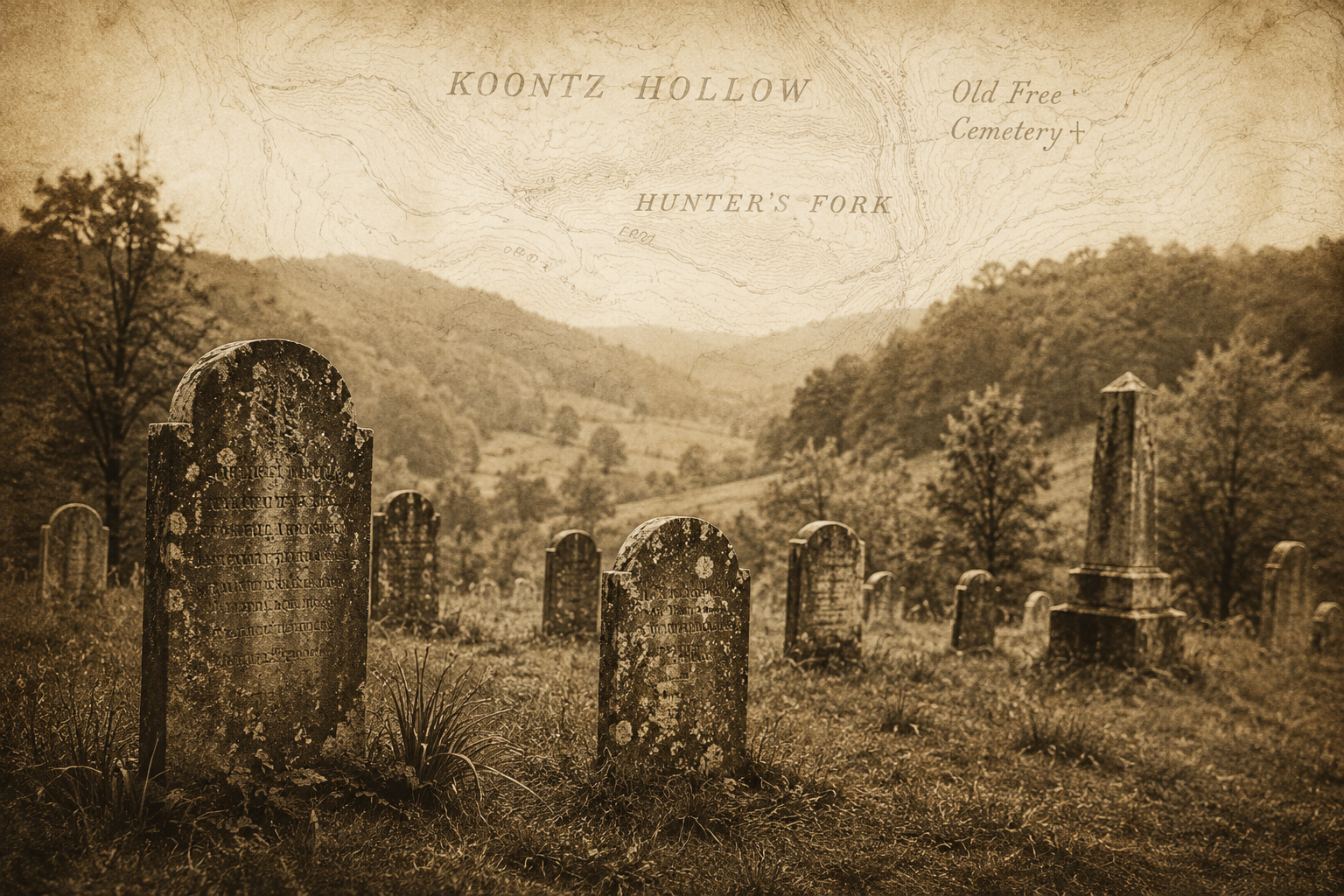
The Old Free Cemetery - The Location where Valley North proposes to run their line across Koontz Hollow Ridge - Kelley Road, across Route 92 into Hunter’s Fork.
Along the route currently proposed for the Valley Link transmission corridor, the landscape transitions from the ridgeline near Wildcat Rock, down the hillside, and across the road into Hunter's Fork. Situated near this crossing is the location of the Old Free Cemetery, a historic burial ground identified on hand-drawn maps that have been preserved through family records and local history.
The cemetery appears alongside other longstanding landmarks documented on these maps, many of which correspond closely with modern topographic features and the existing terrain. The continued alignment between the historic maps and the present-day landscape provides a tangible connection between the region's historical record and the land as it exists today.
Like many rural Appalachian cemeteries, the site serves as a visible reminder of earlier generations who lived, worked, and helped shape the surrounding landscape. Historic burial grounds preserve important links to family history, local settlement patterns, and the development of communities throughout Barbour County.
Over time, portions of the surrounding land remained in private ownership and continued agricultural use. As a result, many of the original grave markers and stone headstones have been lost, displaced, overturned, or weathered by the passage of time. However, the absence of visible markers does not diminish the significance of the cemetery itself. The burial locations remain part of the historical landscape, and the individuals interred there continue to be represented within the archaeological, cultural, and historical record of the area.
The presence of the Old Free Cemetery further illustrates that the Historic Koontz Hollow and Hunter's Fork area is not simply undeveloped land, but a landscape with deep historical associations that span Eastern Woodland Native American activity, early settlement, family farms, community landmarks, and generations of continuous human connection to the land.
Because historic burial sites often retain unmarked graves and subsurface cultural resources long after visible markers have disappeared, any activities proposed within the vicinity should take into account the potential presence of historic burials, archaeological resources, and other cultural resources associated with the historical development of the region.
When viewed together with nearby historic homesteads, documented Eastern Woodland Native artifacts, Wildcat Rock, historic maps, springs and headwaters feeding the greater Sugar Creek watershed, and longstanding agricultural use, the cemetery contributes to a broader cultural landscape whose significance extends beyond individual sites or structures. Preserving the historical record of these interconnected places helps ensure that the history, heritage, and cultural resources of Historic Koontz Hollow, Hunter's Fork, Barbour County, and West Virginia remain visible for future generations.
The Landscape Then and Now
Historic maps preserved through family records continue to correspond closely with modern topographic features, helping document the long-term continuity of the Koontz Hollow and Hunter's Fork landscape. Landmarks such as Wildcat Rock, the Old Free Cemetery, streams, ridgelines, and historic homesteads remain identifiable within the landscape today.
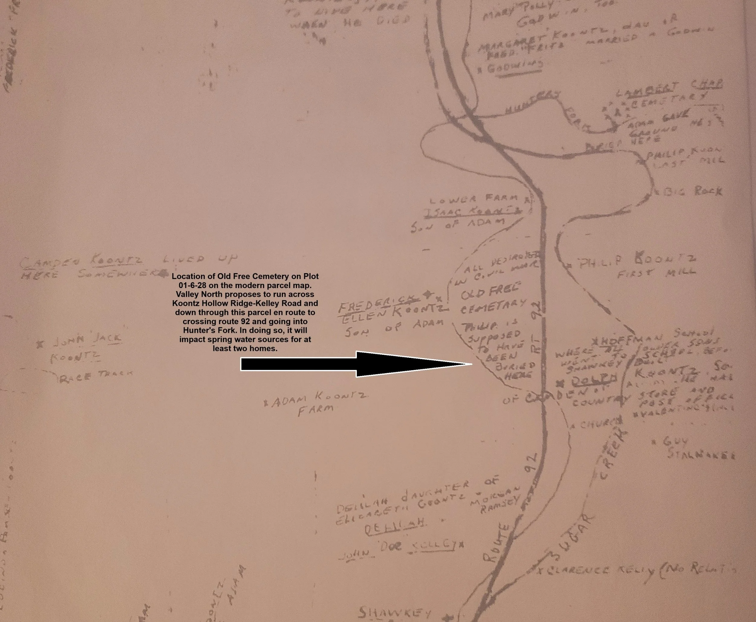
Historic hand-drawn map showing the Old Free Cemetery, homesteads, streams, and other landmarks within Historic Koontz Hollow and Hunter's Fork. Preserved through family records, the map documents locations that have remained part of the landscape for generations.
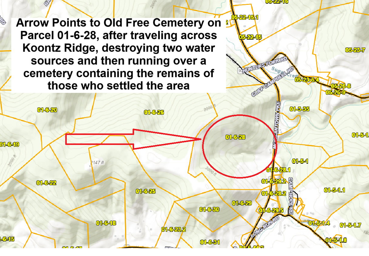
Modern topographic map of Historic Koontz Hollow and Hunter's Fork. Many of the terrain features, ridgelines, streams, roads, and landmarks depicted on the historic map remain readily identifiable today, demonstrating the continuity between the historical record and the present-day landscape.
Springs, Headwaters, and Rural Water Security
The proposed Valley Link corridor crosses a ridgeline that supplies natural springs, headwater tributaries, livestock water sources, and household water systems that have supported Historic Koontz Hollow and Hunter's Fork for generations.
The creator of this website, whose Koontz ancestors are depicted on the Historic Koontz Hollow home page, has provided photographs documenting the current water conditions affecting one of the family properties located along the proposed Koontz Hollow - Kelley Road Valley Link corridor. These conditions exist today and may be further exacerbated if construction activities proceed along Koontz Hollow Ridge and into Hunter's Fork.
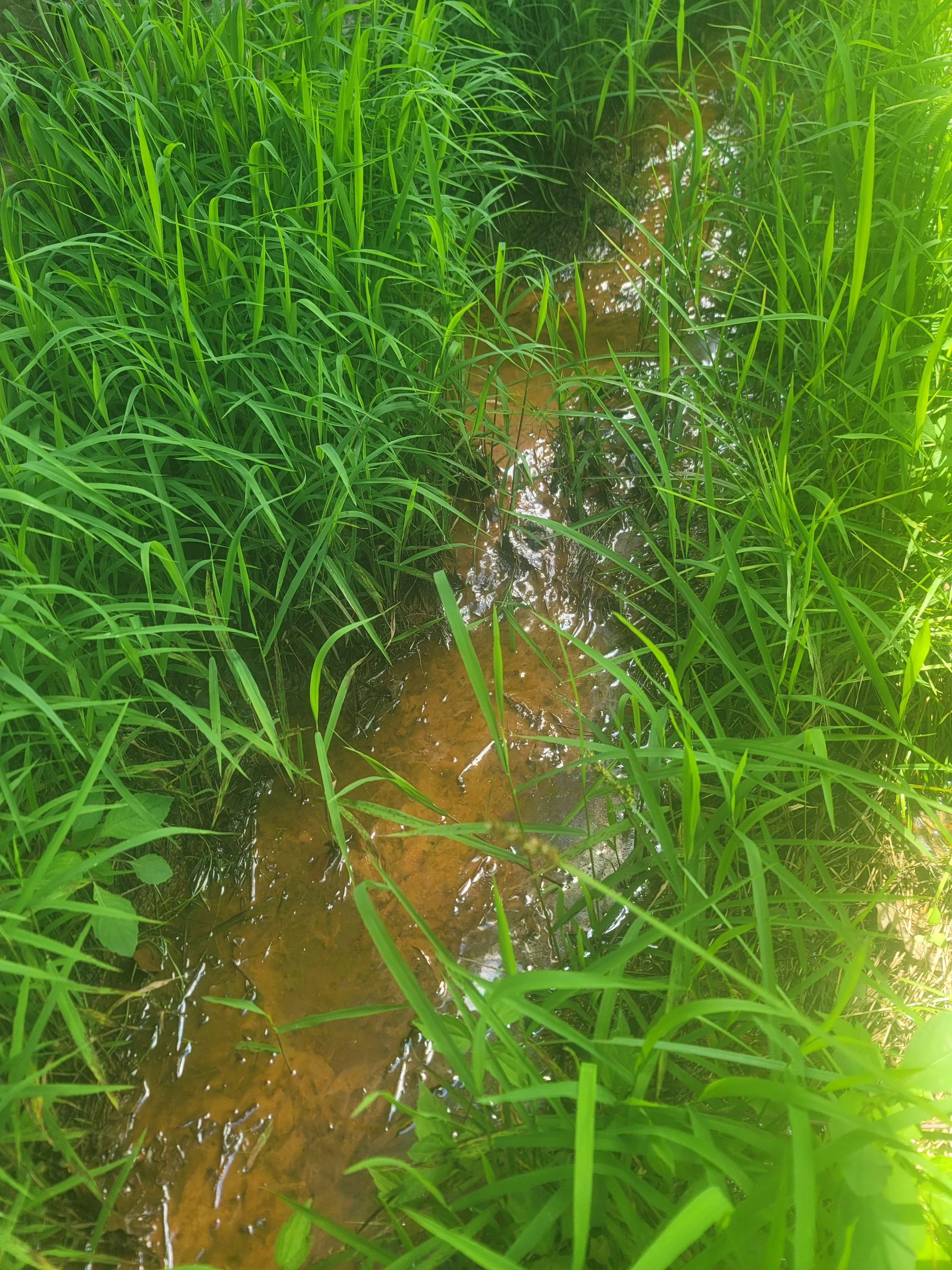
The topographic map below illustrates the location of the remaining spring-fed water source originating from the ridgeline down to the property. This spring contributes to the water supply for the property, feeds into ponds and streams joining the headwaters of Sugar Creek and represents the last remaining viable source of household water available to the homestead.
Water sources in this property already exhibit significant mineral staining, leaving orange deposits on plumbing fixtures, toilets, water bowls, storage containers, and other household surfaces even after treatment. While the family has adapted to these existing conditions while searching for a solution, the continued availability of the water source remains critical to the long-term habitability of the property.
Unlike municipal water systems, rural Appalachian homesteads often depend upon localized springs and groundwater resources that cannot be replaced if damaged or disrupted. Any impacts to the spring, groundwater recharge area, or associated hydrological systems could have consequences extending beyond temporary construction activities.
For this property, the spring is not simply a convenience—it is the last remaining viable water source supporting continued residential use of the farm. The loss or degradation of that resource would raise serious concerns regarding the future habitability of the homestead and the continued use of the property as a working farm within Historic Koontz Hollow and possibly the tributaries feeding into Sugar Creek. feeding cattle and other livestock.
The ridgeline proposed for the Valley Link transmission corridor contains natural springs and groundwater resources that contribute to the headwaters of tributaries feeding the greater Sugar Creek watershed. These springs support downstream ecosystems, agricultural lands, livestock operations, and long-established family homesteads within Historic Koontz Hollow and Hunter's Fork.
At least two farms rely upon water originating from this ridgeline. For one homestead, the spring-fed water source represents the last remaining viable option for a dependable household water supply. Any disruption to the groundwater system, spring flow, or associated recharge areas could have consequences extending far beyond the immediate construction corridor.
Unlike many impacts that can be repaired or replaced, natural spring systems are complex hydrological features that may be difficult or impossible to fully restore once disturbed. Because these waters support homes, cattle, agricultural operations, wildlife habitat, and headwater tributaries within the Sugar Creek watershed, careful evaluation of potential impacts should be an important consideration in any future project review.
The Last Remaining Water Source
A family water supply already under strain could face additional risk if the Valley Link corridor proceeds along Koontz Hollow Ridge and into Hunter's Fork.
Topographic Map of Spring System and Ridgeline Water Source for 622 Kelley Road
Water emerging from the table surrounding the house and from same supply that feeds the house - untreated. Existing water conditions at a Koontz Hollow homestead. Iron and mineral deposits leave significant staining on household fixtures and containers despite treatment measures.
This map illustrates the location where a spring originating higher on Koontz Hollow Ridge emerges at the surface before continuing downslope toward ponds, streams, and tributaries feeding the greater Sugar Creek watershed. During portions of the year, sections of the spring flow may disappear beneath rock formations before reemerging farther downslope.
The spring is part of a larger groundwater system that originates beneath the ridgeline and contributes to water resources supporting nearby farms, livestock, headwater tributaries, and residential use. Previous transmission proposals, including the former PATH corridor, would have crossed portions of this spring system. The currently proposed Valley Link corridor raises similar concerns regarding potential impacts to groundwater recharge areas, spring flow, and the originating water source located higher on the ridge.
Because this spring represents a critical component of the local water supply network, landowners have expressed concern regarding any activities that could affect the long-term integrity of the groundwater system, including the spring's point of origin, recharge areas, and downstream flow paths.
The water sources on the lower part of the property are no longer viable even after treatement, as can be seen from the photos below.

Dog bowl after holding TREATED water

Tank holding TREATED water
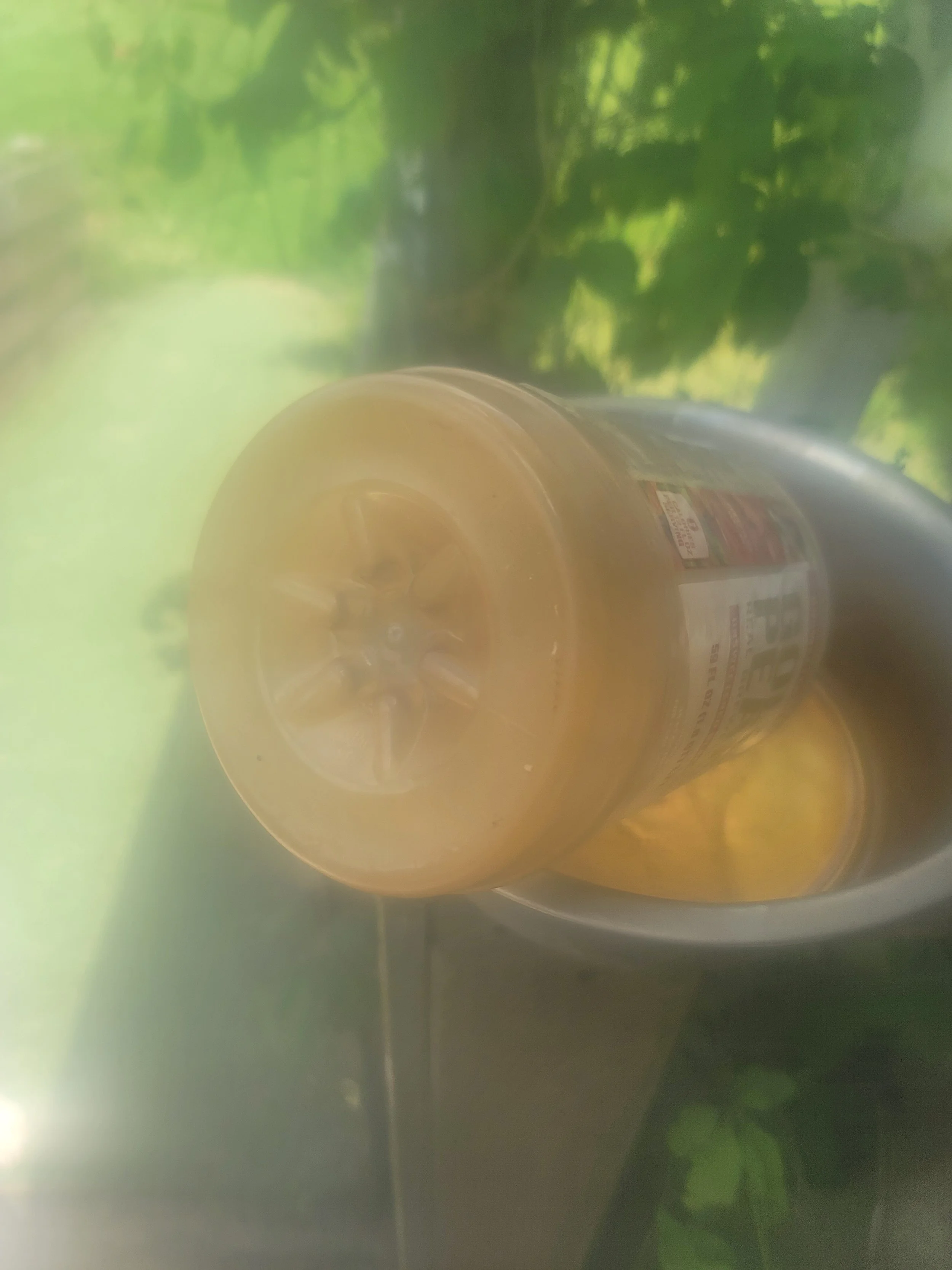
Plastic container stained orange after holding TREATED water
For this property, the spring is not simply a convenience—it is the last remaining viable water source supporting continued residential use of the farm. Previous efforts to improve water quality through treatment systems and other corrective measures have not fully resolved the underlying issues associated with the existing water supply. As a result, the residents planned to rely upon the remaining spring-fed source originating from Koontz Hollow Ridge as the most dependable long-term water solution for the property.
Any impacts to that spring, its recharge area, or the broader groundwater system associated with the proposed Valley Link corridor could raise serious concerns regarding the future habitability of the homestead and the continued viability of a family farm that has remained continuously owned and stewarded by the same family for more than 200 years within Historic Koontz Hollow.
The Rusty Patched Bumble Bee
Recovery of the First Federally Listed Pollinator
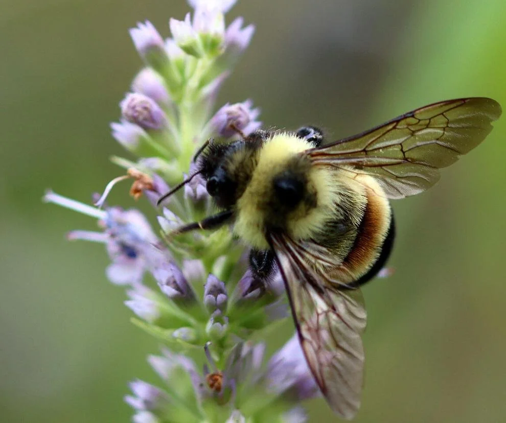
Rusty Patched Bumble Bee (Bombus affinis), a federally endangered pollinator species identified by the U.S. Fish and Wildlife Service as a conservation priority. The entirety of Koontz Hollow and Hunter's Fork area fall within a designated Low Potential Zone established for scientific recovery surveys and additional conservation efforts intended to support long-term species recovery.
Photo credit: Dawn Marsh, U.S. Fish and Wildlife Service (courtesy photo).
Recovery Landscapes and Conservation Opportunities
According to U.S. Fish and Wildlife Service mapping resources, the two southern proposed routes going through Barbour County that include portions of the Koontz Hollow and Hunter's Fork area, fall within a Rusty Patched Bumble Bee Low Potential Zone identified for scientific recovery surveys and additional conservation efforts. While Low Potential Zones do not indicate confirmed occupancy, they form part of a broader recovery strategy intended to support habitat expansion, population monitoring, and long-term conservation of the species.
The Rusty Patched Bumble Bee (Bombus affinis) was listed as endangered under the Endangered Species Act in 2017, becoming the first bumble bee species in the United States to receive federal protection. Historically widespread throughout much of its range, the species experienced a rapid and substantial decline prior to listing. Scientists have identified habitat loss, introduced pathogens, pesticide exposure, climate-related stressors, and population fragmentation as contributing factors.
In 2024, the U.S. Fish and Wildlife Service designated approximately 1.5 million acres of critical habitat for the species across portions of Illinois, Iowa, Minnesota, Virginia, West Virginia, and Wisconsin. Conservation of native bumble bees has been recognized as both an ecological and economic priority because of their role in pollinating native plants, supporting biodiversity, and contributing to agricultural productivity and food security.
The forests, meadows, agricultural lands, flowering resources, and undeveloped habitats associated with Historic Koontz Hollow and Hunter's Fork reflect many of the landscape characteristics that conservation programs seek to maintain and enhance throughout the species' remaining range. As a designated Low Potential Zone identified for additional conservation efforts, the area may contribute to future habitat connectivity and species recovery objectives.
Although critical habitat designations do not create public access rights or convert private property into protected reserves, federal endangered species considerations may become relevant when projects involve federal permitting, federal approvals, federal funding, or other federal agency actions. Because the proposed Valley Link transmission project is an interstate infrastructure project requiring extensive regulatory review, additional evaluation of pollinator resources and habitat conditions may warrant consideration as part of any future environmental review process.
The purpose of documenting these resources is not to establish the confirmed presence of the Rusty Patched Bumble Bee within Koontz Hollow or Hunter's Fork, but rather to recognize the area's location within a federally identified recovery landscape and to encourage further study before irreversible changes are made to the surrounding environment.
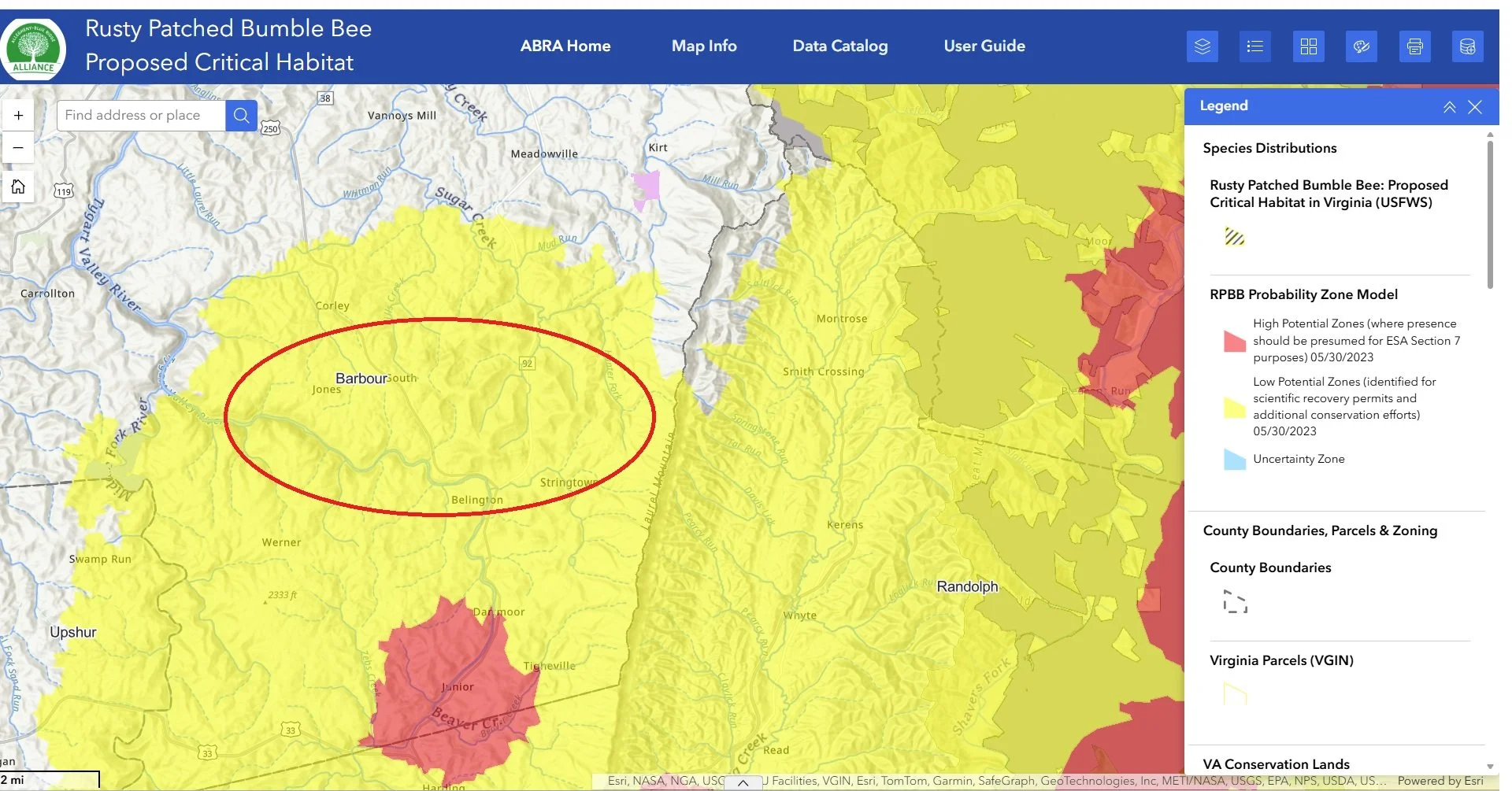
Map of the Rusty Patched Bumble Bee Critical Habitat as taken from the ARCGIS website. The entire yellow area is a buffer zone and the area within the red circle is Koontz Hollow and Hunter’s Fork, and the areas that both southern proposed routes of Valley North run through.

Archaeological Resources and Native American Presence
The Koontz Hollow and Hunter's Fork area contains documented evidence of Eastern Woodland Native American presence, including artifacts recovered from wooded areas associated with the historic Koontz Homestead and adjacent lands, including the property now known as Wildcat Rock. These findings, together with the area's natural features, ridgelines, water sources, and shelter locations, suggest a landscape that was utilized by Native peoples long before European settlement.
Of particular concern is the fact that portions of the proposed Valley Link corridor would traverse the same ridgeline and surrounding areas where Native American artifacts have previously been documented. Ground disturbance associated with transmission line construction, access roads, vegetation clearing, foundation excavation, and related activities has the potential to affect archaeological resources that remain undiscovered or undocumented beneath the surface.
While not all cultural resources are visible on the landscape today, archaeological sites often retain important information about past human activity, settlement patterns, travel routes, and land use. Once disturbed, that information may be permanently lost.
Additional archaeological investigation and documentation may therefore be warranted before irreversible changes are made to areas known to contain or be associated with historical and pre-contact cultural resources.
Visitors interested in learning more about the documented Eastern Woodland Native American artifacts, Wildcat Rock, historic maps, and the broader cultural history of the area may explore the Artifacts, Culture, and Preservation section of this website.